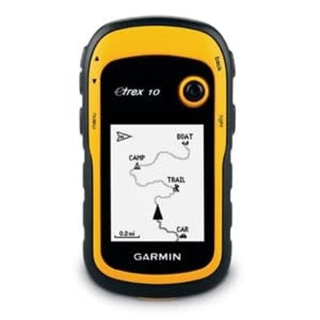
Garmin eTrex 10
Rugged handheld GPS with many features. Global base map. 2.2-inch monochrome display, sunlight-readable screen. Read more..
24/7 Online winkelen
Flex-Delivery-Service
Fysieke winkel
Veldhoven (NL)Gratis verzending NL/BE vanaf €150
Product description
Garmin eTrex 10
Robust handheld GPS with many features.
- Global base map
- 2.2-inch monochrome display, sunlight-readable screen
- GPS and GLONASS satellites for faster positioning
- Paperless geocaching
- Battery life of 25 hours with 2 AA batteries
Only Garmin can improve the eTrex. The new eTrex 10 still has all the core features, has rugged construction, is affordable and the batteries have long battery life. This makes the eTrex the most reliable GPS device available. We have improved the user interface and added a basic map of the world, paperless geocaching and support for accessories that attach to the back. You recognize the name. You recognize the quality. But the eTrex 10 is a totally new device - one that can only come from Garmin.
See the road
eTrex 10 has an improved 2.2-inch screen that is easy to read in all lighting conditions. The eTrex 10 is durable and waterproof; made to brave the elements. The user-friendly interface allows you to enjoy the outdoors more and spend less time looking up information. The eTrex 10 has legendary toughness and is resistant to dust, dirt, moisture and water. This legendary navigator truly stands up to the elements.
Have fun geocaching
The eTrex 10 supports GPX geocaching files so you can download geocaches and information directly to your device. Go to OpenCaching.com and start your geocaching adventure. By not using paper, you not only save the environment but also work more efficiently. The eTrex 10 stores and displays important information, including location, terrain, difficulty, and tips and descriptions. So you no longer have to manually enter coordinates and carry paper printouts. Upload the GPX file to your device and you can start looking for caches right away.
Precise positioning
Thanks to the ultra-sensitive GPS receiver with WAAS functionality and HotFix® satellite prediction, the eTrex 10 determines your position quickly and accurately. Your GPS position is maintained even without a view of the sky and in ravines. The benefit of this speaks for itself; whether you are going deep into the woods or are near tall buildings and trees, you can count on the eTrex 10 when you really need it.
The world in your hand
The new eTrex series is the first consumer series of receivers that can simultaneously track GPS and GLONASS satellites. GLONASS is a system developed in the Russian Federation that is expected to be completed in 2012. The time it takes receivers to determine your position based on signals from GLONASS satellites is (on average) about 20 percent shorter than GPS signals. And if you use both GPS and GLONASS, the receiver can receive up to 24 more satellites than with GPS alone.
Scope of delivery:
- eTrex 10
- USB cable
- Manual
General
LENSES
acrylic
PHYSICAL DIMENSIONS 5.4 x 10.3 x 3.3 cm (2.1 x 4.0 x 1.3 in.)
WEIGHT 141.7 g (5 oz.) with batteries
WATER RESISTANCE IPX7
MIL-STD-810 No
Touchscreen No
TYPE SCREEN transflective, monochrome
SCREEN SIZE, WXH 3.6 x 4.3 cm (1.4 x 1.7 in.); 5.6 cm (2.2 in.) diagonally
SCREEN RESOLUTION, BXH 128 x 160 pixels
BATTERY 2 AA batteries (not included); NiMH or Lithium recommended
BATTERY LIFE 25 hours
MEMORY/HISTORY no
INTERFACE mini USB
Maps And Memory
PRE-INSTALLED CARDS no
POSSIBILITY TO ADD CARDS No
BASIC CARD Yes
Reviews
Specifications
eTrex 10
0 reviewsReview Garmin eTrex 10
Rugged handheld GPS with many features. Global base map. 2.2-inch monochrome display, sunlight-reada..


